

Africa’s agriculture sector is entering a new phase of digitalisation in which satellite imagery and artificial intelligence are increasingly being used to measure farmland, monitor crops, forecast production and identify climate-related risks. Namibia’s decision to terminate a $2.4 million crop-monitoring contract with U.S.-based 6th Grain Corporation in August has highlighted the importance of procurement and governance in deploying such systems, but the underlying technology push continues elsewhere on the continent. Nigeria, Kenya and Rwanda are already developing national platforms that use satellite data and artificial intelligence to generate agricultural intelligence, signalling a broader shift towards data-driven management of food production.
Namibia’s Ministry of Agriculture, Fisheries, Water and Land Reform formally terminated its Remote Sensing Agricultural Services Agreement with 6th Grain after an internal review found that the arrangement did not meet the legal and procedural requirements applicable to government contracts. The agreement, which was signed in June 2026, was valued at about N$39.5 million, or approximately $2.4 million, and was intended to run for one year. It was designed to combine satellite imagery, remote sensing, geospatial analytics and artificial intelligence to monitor key crops including maize, mahangu, sorghum, cowpea and wheat. The proposed system would have produced crop maps, crop-health information, production forecasts, land-suitability assessments and drought-risk analysis.

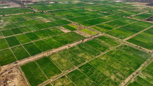
The termination does not, however, diminish the wider significance of the technology Namibia had sought to deploy. Across Africa, governments are under pressure to obtain more timely and reliable information about agricultural production as climate variability, population growth, food-import costs and pressure on public finances make agricultural planning more consequential. Conventional agricultural surveys can be expensive and time-consuming, particularly across large territories or areas where field access is difficult. Satellite-based Earth observation provides a means of collecting information across large areas repeatedly, while artificial intelligence can process those datasets to identify patterns and generate estimates for government agencies and other users.
Nigeria is among the countries moving most visibly in this direction. In July 2026, the Federal Government signed an agreement with OCP Africa and Ground Truth Analytics to develop the National Agro-Productivity System, or NAPS, described as the country’s first national crop-monitoring platform powered by satellite imagery and artificial intelligence. The system is intended to provide information on agricultural land, crop distribution, production performance and emerging food-security risks. Ground Truth Analytics says the platform can analyse satellite imagery at frequent intervals, identify individual farms, determine crops and monitor crop development, creating a national layer of agricultural intelligence for public-sector planning.
The Nigerian initiative is significant because it connects agricultural data with broader questions of food-security planning and resource allocation. Better estimates of cultivated land and expected production can help governments assess potential food shortages, plan imports, target agricultural support and understand where climate or other production risks are emerging. For farmers and agribusinesses, more granular information can also support decisions around inputs, insurance, financing and supply chains. The value therefore lies not simply in generating satellite images but in converting those images into information that can influence decisions across the agricultural economy.
Kenya has taken a similar approach through its Crop Measurement and Evaluation initiative, known as CroME, launched in February 2026. Led by the Kenya Space Agency and the Ministry of Agriculture and Livestock Development, the initiative combines satellite imagery, artificial intelligence and geospatial models to create national agricultural datasets. CroME is designed to produce crop maps, identify crop types, define field boundaries, monitor crop conditions and generate yield forecasts, while also supporting crop-damage detection and early-warning systems. The initiative involves the Kenya Space Agency, the Ministry of Agriculture, NASA Harvest, Microsoft’s AI for Good Lab and other public and private partners.
Kenya’s experience also illustrates why the value of agricultural AI depends on the quality of the underlying data. Satellite models must distinguish between crops, farmland and other land uses, while yield estimates need to be calibrated against conditions on the ground. Philip Thigo, Kenya’s Special Envoy on Technology, has highlighted the role of Earth-observation data and AI-driven geospatial models in producing cropland maps, identifying crop types, defining field boundaries and forecasting yields. Kenya Space Agency Board Chair Maj Gen (Rtd) Amb. Joff Otieno Makowenga has similarly linked the use of space technology to more timely and accurate decision-making in agriculture.
Rwanda has also been developing the infrastructure needed to integrate satellite information into agricultural decision-making. The Rwanda Space Agency’s Geospatial Hub, or GeoHub, uses satellite imagery and artificial intelligence to monitor farmland, while its broader smart-agriculture programme is designed to combine satellite data with machine-learning models for crop classification, yield prediction and farmland delineation. The agency’s Chief Technology Officer, Georges Kwizera, has described the GeoHub as a central platform for geospatial information, while the agency’s current programme includes agriculture among the sectors in which Earth-observation data is being applied.
The similarities between the systems being developed in Namibia, Nigeria, Kenya and Rwanda point to a wider change in the role of agricultural statistics. Satellite imagery can provide repeated observations of cultivated land and crop conditions, while AI can process large volumes of geospatial information more rapidly than conventional manual approaches. When combined with weather information, field observations and agricultural statistics, these systems can provide governments with a more continuous picture of production than periodic surveys alone.
That capability has particular relevance as African agriculture becomes more exposed to climate variability. Droughts, floods, irregular rainfall and changing growing conditions can alter production within a single season, creating consequences for food prices, imports, public expenditure and rural incomes. Early identification of crop stress or changes in planted areas can give governments more time to assess potential impacts and consider responses. Satellite-based monitoring can also support disaster assessment by identifying areas affected by floods, drought or other events when physical surveys may be difficult or delayed.
But the expansion of agricultural intelligence also introduces a less visible policy question: who controls the data and the systems used to interpret it? The Namibia case demonstrates that technology procurement cannot be separated from public-sector governance. A government may acquire access to satellite imagery and AI models through an external technology provider, but long-term value depends on whether domestic institutions can understand, validate, manage and use the resulting information after the original contract ends.
Data ownership, model transparency, cybersecurity and interoperability are therefore likely to become increasingly important as national agricultural information systems expand. Governments will need to establish clear rules over where agricultural data is stored, who can access it, how datasets can be shared and whether models can be independently audited. The issue extends beyond government agencies because agricultural intelligence can have commercial value for insurers, lenders, commodity traders, input suppliers and agribusinesses.
The skills required to maintain these systems are equally important. Building a national crop-monitoring platform is not simply a matter of purchasing satellite data or artificial-intelligence software. Governments need specialists in remote sensing, geographic information systems, machine learning, agricultural science, meteorology and data governance. They also need ground-truthing systems capable of testing whether satellite-derived estimates accurately represent conditions on farms. Without those capabilities, countries risk becoming dependent on external providers for both the technology and the interpretation of their own agricultural data.
The financing model will also determine whether these systems become permanent public infrastructure or remain short-term technology projects. Satellite subscriptions, cloud computing, model development, data storage, system maintenance and technical personnel all create recurring costs. Governments therefore face the challenge of moving beyond initial project financing towards sustainable budgets and institutional arrangements that allow agricultural intelligence platforms to operate across multiple growing seasons.

For Africa, the strategic opportunity is substantial. Agricultural data can become an input into decisions about food security, climate adaptation, agricultural finance, insurance, land management and public investment. As Nigeria develops NAPS, Kenya expands CroME and Rwanda develops its GeoHub and smart-agriculture capabilities, the continent is building a growing base of national experience in applying Earth observation and AI to agriculture.
Namibia’s cancelled contract consequently offers a wider lesson for the continent. The challenge is not whether satellite imagery and artificial intelligence can be used to monitor agriculture; multiple African programmes are already demonstrating that they can. The more consequential question is how governments structure procurement, build domestic technical capacity, protect agricultural data and finance these systems over the long term. As agricultural intelligence becomes increasingly connected to food security and climate-risk management, control over the data and capabilities behind these technologies could become as important as access to the technology itself.