

Kenya is exploring the use of satellite imagery, geospatial technologies and Earth observation data to strengthen national forest monitoring, as the government seeks more reliable evidence on forest-cover change and the survival of trees planted under its 15 Billion Tree Growing Programme. The Kenya Forest Service (KFS) and Kenya Space Agency (KSA) began formal discussions on August 12, bringing together the country’s forestry and space institutions around a system that could improve the measurement of deforestation, forest degradation and restoration outcomes. The move comes as Kenya faces an estimated annual loss of 84,716 hectares of forest to deforestation and an additional 14,934 hectares affected by degradation, according to the National Forest Status Report 2024.
The proposed cooperation between KFS and KSA comes at a critical point for Kenya’s restoration agenda. The government’s Mission 15B, also known as Jaza Miti, aims to grow 15 billion trees by 2032 while restoring 10.6 million hectares of degraded landscapes and increasing national tree cover to 30%. The programme covers forests, water towers, rangelands, farmlands, wetlands, marine ecosystems and urban areas, making accurate monitoring increasingly important as the scale of implementation expands.
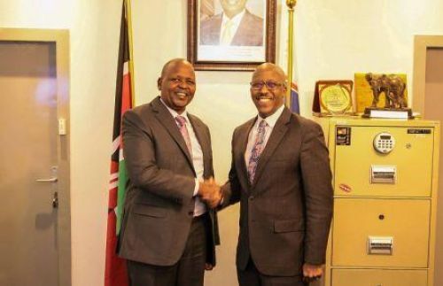
KFS Director Alex Lemarkoko and KSA Director General Brig. Hillary Kipkosgei discussed potential cooperation involving satellite imagery, geospatial technologies and Earth observation data. The proposed system is expected to support forest-cover monitoring, assessment of reforestation programmes and the national forest resource assessment. KFS currently identifies Lemarkoko as Chief Conservator of Forests, while the Kenya Space Agency identifies Kipkosgei as its Director General.
The economic case for better forest intelligence is substantial. Kenya’s 2024 forest assessment estimated that deforestation and degradation are costing the economy about Sh534 billion annually, equivalent to at least 3% of GDP, through losses associated with ecosystem services, rainfall, water quality and soil protection. Forest land accounts for about 8.8% of the country’s territory, leaving Kenya below the 10% forest-cover threshold established in the Constitution.
Those figures underline why measuring forest change is not simply an environmental exercise. Forests underpin water supplies, agricultural productivity, hydropower systems, soil conservation and rural livelihoods. Degradation in important catchments can affect water availability downstream, while declining vegetation cover can increase erosion and reduce the capacity of landscapes to absorb climate shocks. Better forest data can therefore support decisions affecting agriculture, water infrastructure, disaster preparedness and local economies.
Satellite monitoring could also help address one of the central measurement challenges surrounding large-scale tree-growing programmes: distinguishing between trees planted and trees that survive. Kenya has invested heavily in expanding the number of seedlings planted under Jaza Miti, but the environmental value of the programme ultimately depends on establishment, survival and long-term growth rather than planting numbers alone.
The JazaMiti digital platform already provides a foundation for this type of monitoring. According to the Kenya Forestry Research Institute, the application was developed to track progress towards the 15 billion tree target and support species-to-site matching. KEFRI also reports that the platform can record planted trees and enable growers to monitor survival and mortality rates over time.

Satellite data could complement those ground-level records by providing a broader view of restoration sites. Remote sensing can help identify changes in vegetation cover across large and sometimes difficult-to-access landscapes, while repeated imagery can provide evidence of whether restoration areas are retaining vegetation over time. Combined with field verification and information captured through JazaMiti, such systems could give government agencies a more complete picture of restoration performance.
This distinction matters for public finance. Kenya’s restoration programme involves public institutions, county governments, communities, development partners and private-sector organisations. The State Department for Forestry describes Mission 15B as a whole-of-government and whole-of-society initiative, while its current strategy calls for restoration of 10.6 million hectares and the planting of 15 billion trees.
As resources are allocated across thousands of restoration activities, stronger monitoring could help policymakers identify which interventions are producing durable ecological outcomes and where additional investment or corrective action is required. It could also improve accountability around restoration claims and provide more consistent evidence for climate-finance and ecosystem-restoration initiatives.
The scale of the challenge is illustrated by the contrast between Kenya’s restoration ambitions and its continuing forest losses. The government has made progress on tree-growing activities, with recent reports documenting substantial numbers of seedlings distributed to counties. In May 2026, for example, KFS received more than three million indigenous and climate-resilient seedlings from Earthbanc for distribution to several counties.
But planting more trees while losing existing forest remains a difficult equation. Kenya’s forestry authorities have increasingly emphasised both tree growing and the protection of existing ecosystems. In April, the State Department for Forestry highlighted the need for measurable improvements in tree survival rates and ecosystem restoration outcomes, while KFS continues to oversee forest protection and management.
The proposed space-technology partnership could therefore shift the emphasis from activity reporting towards outcome measurement. Instead of asking only how many seedlings have been planted, authorities could increasingly assess how much vegetation has survived, where restoration is succeeding, where forest cover continues to decline and which landscapes require intervention.
There are also implications for Kenya’s climate policy. Forests are a major component of national climate mitigation and adaptation efforts, while the government’s restoration strategy links ecosystem recovery with climate resilience, livelihoods, food security and water resources. The State Department for Forestry has also called for stronger investment and partnerships to accelerate restoration and sustainable forest management.
For Africa more broadly, Kenya’s approach illustrates the growing role of Earth observation in environmental governance. Many African countries face similar difficulties in monitoring forests across large territories where ground-based surveys can be costly, slow or difficult to repeat frequently. Satellite data can provide a common layer of information for national forest inventories, restoration programmes and climate-related monitoring, although satellite observations still need to be combined with credible field data and institutional capacity.
The proposed KFS-KSA collaboration is therefore not simply about putting more technology into forestry. Its significance lies in whether Kenya can use space-based information to improve the quality of decisions around one of the country’s largest environmental and public-investment programmes. If satellite monitoring is effectively integrated with field assessments and existing digital systems, it could provide a stronger evidence base for measuring forest restoration, allocating resources and evaluating whether Kenya’s 15 billion tree ambition is translating into lasting changes on the ground.
For Kenya, the next test will be implementation: establishing reliable data systems, integrating information across agencies and ensuring that satellite-derived assessments are converted into practical decisions by forest managers, policymakers and communities. The value of the technology will ultimately be measured not by the volume of imagery collected, but by whether it helps the country protect existing forests, improve tree survival and demonstrate measurable restoration outcomes.