


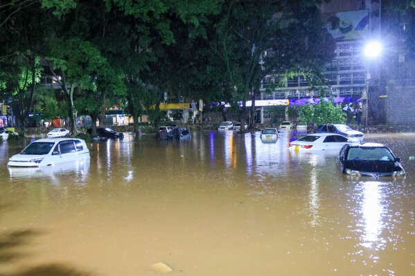
In early March 2026, torrential rains brought parts of Nairobi to a standstill. Flash floods swept through roads, submerged neighbourhoods, and disrupted operations at Jomo Kenyatta International Airport. Vehicles were washed away, power infrastructure was damaged, and thousands of residents were displaced. At least 66 people have died across Kenya (as of the 16th of March), with Nairobi accounting for a significant portion of the casualties.
Meteorological data showed just how intense the rainfall was: 112 mm of rain fell within 24 hours, more than the city’s average rainfall for the entire month of March. Yet for many historians, planners, and environmental researchers, Nairobi’s recurring floods are not a surprise. The city’s vulnerability was recognized more than a century ago.
A city built on a swamp
When Nairobi was being established as a railway depot for the Uganda Railway in the early 20th century, engineers already warned about the suitability of the site.
In May 1906, colonial administrator Sir James Sadler wrote to Winston Churchill, describing Nairobi as “a depression with a very thin layer of soil or rock… water-logged during the greater part of the year.” Engineers had earlier recommended relocating the settlement to higher ground in the nearby hills. But railway planners dismissed the concern, believing Nairobi would remain a small railway outpost, primarily an “Indian township”, rather than a major city.
Their confidence overlooked the environmental realities of the landscape.
Early warning signs
The consequences emerged quickly. In 1901 and 1904, outbreaks of plague struck the young settlement, fueled in part by swampy and unsanitary conditions. Colonial medical officials raised alarms.
Dr. W. H. MacDonald, the medical officer responsible for the town, argued that Nairobi had been built in the wrong place and recommended relocating it to higher ground near present-day Kikuyu. But relocation was rejected by the colonial administration because it was considered too expensive. Instead, under the leadership of Sir Charles Eliot, authorities opted for a cheaper solution: reclaiming the swamp. Drainage channels were excavated along the Nairobi River, and low-lying areas were filled with soil from railway construction.
The swamp was “tamed,” but the fundamental geography remained unchanged.
Geography still dictates the city
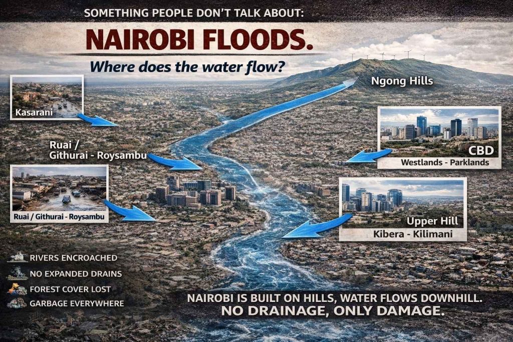
More than a century later, Nairobi’s physical landscape continues to shape how water moves through the city. Although it often feels flat in the urban core, Nairobi is built across a series of hills and valleys. Rainwater naturally flows downhill through river catchments and tributaries.
- Water from Kasarani drains toward Ruai and Roysambu.
- Water from Ngong flows toward the Nairobi Central Business District, Westlands, and Parklands.
- Water from Eastleigh drains toward Mathare.
- Water from Upper Hill flows downhill toward Kibera and Kilimani.
Water always follows gravity. What determines whether rain becomes a disaster is not the rainfall itself, but the city’s ability to manage it.
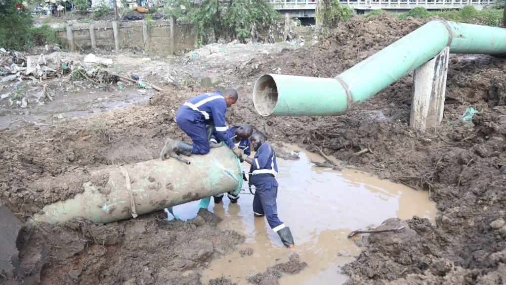
Urban growth without drainage
As Nairobi expanded rapidly after independence, urban growth frequently outpaced infrastructure planning. Wetlands and riparian zones along the Nairobi River and its tributaries were gradually encroached upon. Forest cover in the surrounding catchments declined. Drainage channels designed for a much smaller colonial town were never scaled to match the population of a modern metropolis.
Researchers have long warned that rapid urbanization, development on floodplains, and weak enforcement of land-use planning regulations have significantly increased flood risks in Nairobi. In many neighbourhoods, particularly informal settlements such as Kibera, Mathare, and Mukuru, stormwater infrastructure is limited or absent. During heavy rains, water has nowhere to go. Garbage blocking drains, buildings constructed directly over waterways, and degraded riverbanks further worsen the problem.
Climate change is raising the stakes!
The challenge is now compounded by climate change. Scientists increasingly link the growing intensity of rainfall events in East Africa to global warming, which is making extreme weather more frequent and severe. The 2026 floods follow a pattern seen across recent years, including devastating floods across Kenya in 2024 that displaced hundreds of thousands of people. What was once an occasional disaster is becoming a recurring seasonal threat.
The lesson Nairobi keeps ignoring?
Rain is natural. Hills are natural. Rivers are natural.
Flood disasters, however, are often the result of human decisions. More than a century ago, engineers and medical officials warned that Nairobi’s location and drainage would pose long-term risks. Today, the same warnings echo through urban planning reports, academic research, and environmental assessments.
The floods of 2026 are therefore not just a climate event. They are also a reminder of a deeper governance challenge: a city that has continued to expand without fully accounting for the geography it sits upon.
Until Nairobi confronts that reality by protecting rivers, restoring wetlands, and building drainage systems that match its growth, the city will remain vulnerable.
And every rainy season will continue to reveal what history already knew.