


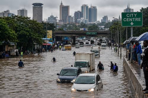
Nairobi’s preparations for the October–December 2026 rainy season are exposing a wider challenge in the city’s flood management: drainage improvements may reduce surface water accumulation on major roads, but they cannot adequately protect residents living in flood-prone informal settlements without changes to land-use planning, housing policy and community-level disaster preparedness.
The Nairobi City County Government has identified 227 flood-prone hotspots across the capital and launched a multi-agency response involving drainage clearance, river rehabilitation, emergency coordination and planned shelters. The preparations follow Kenya’s August 2026 seasonal forecast, which projected above-average rainfall across approximately 80% of the country during the October–December short rains, with prolonged wet spells and occasional isolated storms.
The county’s response includes drainage and flood-mitigation projects, with reported allocations of KSh2.4 billion, including KSh2 billion for drainage improvements along 19 flood-prone roads. Governor Johnson Sakaja has also said that 26 of 61 critical drainage sites had been cleared as the city prepared for the rainy season. The county has worked with agencies including the Kenya Red Cross, Kenya Urban Roads Authority, Kenya National Highways Authority and Nairobi Rivers Commission.

These measures address an important part of Nairobi’s flood exposure. Blocked drains, accumulated waste, inadequate stormwater infrastructure and restricted river channels can increase the speed and severity of flooding during heavy rainfall. However, research published by the World Resources Institute (WRI) in July 2026 argues that the city’s recurring flood crisis is also shaped by settlement patterns, the loss of natural drainage systems, weak enforcement of land-use regulations and fragmented institutional responsibility.
The distinction is significant because Nairobi’s flood risk is not distributed evenly across the city. Major roads and commercial corridors are important to the movement of people and goods, but residents of informal settlements along the Nairobi, Mathare and Ngong rivers face a different level of exposure. In places such as Mathare, Mukuru, Kayole and parts of Kahawa West, flooding can destroy homes, contaminate water supplies and interrupt the informal economic activities on which households depend.
The WRI report, Flooding in Nairobi’s Informal Settlements: Advancing Equitable and Resilient Solutions, examined the March–May 2024 floods through geospatial analysis, flood modelling, policy research and household surveys in Kibera, Mukuru Viwandani and Mathare. It found that nearly 21,000 families were displaced during the 2024 floods, while more than 147,000 cases of waterborne disease were reported. The flooding also damaged roads, bridges, homes and community infrastructure.
The report identifies a combination of physical and institutional factors that intensify the effects of heavy rainfall. Nairobi’s west-to-east slope and river network influence how water moves through the city, while compacted soils, expanding built-up surfaces and the loss of wetlands and riparian vegetation reduce the landscape’s capacity to absorb and manage runoff. Settlement in floodplains and river corridors further increases the number of people and assets exposed to rising water.
Urban expansion has intensified these pressures. A University of Nairobi study examining land-use changes between 1988 and 2010 found that built-up areas and open land increased by approximately 438%, while agricultural and riparian vegetation declined by about 96%. The findings illustrate how development has altered the city’s natural drainage and water-retention systems over time.
Population growth has also increased pressure on available land and housing. Nairobi’s population rose from approximately 350,000 at independence to nearly 4.4 million in the 2019 census. Informal settlements account for a substantial share of the city’s residents while occupying a relatively small proportion of its land. The Kenya Institute for Public Policy Research and Analysis estimates that approximately 60% of Nairobi’s population lives in informal settlements, which occupy about 6% of the county’s land.
For many households, settlement in flood-prone areas is linked to affordability and proximity to employment rather than a lack of awareness about environmental risks. More than 90% of residents in some informal settlements are tenants, meaning they often have limited control over housing quality, land-use decisions or the structural safety of buildings. Moving to safer locations can also mean losing access to casual employment, markets, transport connections and social support networks.
The consequences of flooding therefore extend beyond property damage. The WRI research documents disruptions to sanitation, health services, education and household livelihoods. Flooded pit latrines and contaminated water increase the risk of waterborne illnesses, while traders and small businesses can lose stock and working capital. Children may miss school when pathways and facilities become inaccessible, and women and children face additional protection risks when displacement forces families into temporary shelters.
The effects are particularly difficult to reverse for households with limited savings or access to insurance. A family that loses a home, business inventory or essential documents may take months to recover, even after floodwaters have receded. These costs are not necessarily captured by conventional county progress indicators, which tend to focus on drainage works, cleared channels, infrastructure repairs and the number of identified hotspots.
The March 2026 floods again demonstrated the scale of the city’s exposure. Data compiled by the Copernicus Emergency Management Service, citing Kenya’s Ministry of Interior, recorded 37 flood-related deaths in the Nairobi region between 1 and 24 March. The wider national emergency affected several counties, illustrating the difficulty of managing extreme rainfall through infrastructure interventions alone.
The current response raises questions about how the county measures preparedness and distributes resources. Drainage improvements can reduce immediate hazards, but they do not address the underlying reasons why households continue to live in locations exposed to repeated flooding. Nor do they guarantee that residents will have safe accommodation, accessible evacuation routes or financial support when warnings are issued.
The WRI report recommends a broader approach that combines infrastructure investment with rights-based relocation, restoration of wetlands and riparian corridors, green-grey infrastructure, improved early-warning systems and stronger community participation. These interventions would require coordination between county and national authorities, utility providers, humanitarian organisations and residents.
One priority is to establish social indicators alongside infrastructure targets. Tracking displacement, waterborne disease, school attendance, livelihood losses and access to emergency shelters would provide a clearer picture of how flooding affects households and whether public interventions are reducing vulnerability.
Anticipatory financing could also help households prepare before heavy rainfall reaches critical levels. Cash transfers and other forms of targeted support, activated through reliable weather warnings, could enable vulnerable families to secure essential supplies, protect assets or temporarily relocate. Such measures would need transparent eligibility criteria and coordination with existing social protection programmes.
Relocation and river rehabilitation present another policy challenge. Removing structures from riparian land may reduce exposure, but evictions without affordable alternative housing can push families into other unsafe locations or lead them back to the same flood-prone areas. Resettlement plans therefore need to account for housing costs, employment access, sanitation and the needs of tenants as well as property owners.
Upgrading informal settlements in place, where technically and environmentally feasible, could also reduce risk. Improved stormwater drainage, sanitation, solid-waste collection and accessible evacuation routes would help address immediate vulnerabilities while longer-term land-use planning protects river corridors and natural drainage systems.

Community participation is central to these measures. Residents often have detailed knowledge of local flood patterns, blocked drainage points, evacuation routes and households requiring assistance. Linking community disaster committees to ward-level planning and developing early-warning communication through mobile alerts, community radio and local health networks could improve the speed and reach of emergency responses.
Nairobi’s preparations for the 2026 short rains represent a more coordinated effort than a response focused solely on emergency rescue and recovery. However, the effectiveness of the programme will depend on whether the city can connect infrastructure investment with housing, public health, social protection and land-use policy.
The challenge is not simply to move rainwater away from roads. It is to reduce the number of people forced to live in places where flooding repeatedly threatens their homes, health and livelihoods. As the rainy season progresses, the measure of Nairobi’s preparedness will be whether vulnerable communities can remain safe and recover more quickly, not only whether major roads reopen after the water recedes.